Chiricahua Nat'l Monument Hiking Trip
>> Thursday, November 19, 2009

Trail info: Echo Canyon (start), Hailstone, Mushroom Rock, Inspiration Point, Big Balanced Rock, Heart of Rocks, Sarah Deming, Lower Rhyolite Canyon (end) / Total Mileage: 9.8 / Elevation change: 6780 (start) - 6330 - 7010 - 5400 (end) generally gradual changes / Note: The best way to hike this is to sign up for the free shuttle in the visitor center which leaves at 8:30am and drops you off at the Echo Canyon trail head. You then hike back to the visitor center. (This also makes your hike mostly downhill!)
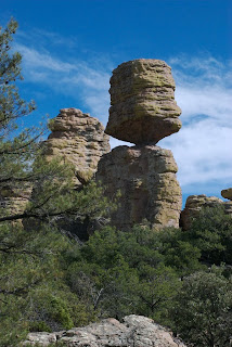
I spent a few days camping in the Chiricahua's, but the main event was this hike combo, which I took at a leisurely pace and made a day out of it. Only through pictures or seeing it for yourself can one truly appreciate the awesomeness of this area. Out of all the places I've traveled to, this park is without question one of my all time favorites. Few trails do I return to again and again to hike, but this is one of them (I think this was my 4th time).  This is a land of impressive volcanic formations that look similar to stalagmites in a cave; the Apache called these spires, "standing up rocks." These stunning pillars cover the hillside, many formed in ways as to defy gravity. The trails not only provide fantastic views of these features but place you in their midst, allowing you to walk amongst their majesty. Unlike so many trails which feature one main attraction or an endpoint with some grand view, these trails are just mile after mile of incredible scenery.
  The day was beautiful, although quite windy and cool at times. I kept putting on and taking off layers as I hiked. Nearing the end of the season there were few others out on the trails. I had hoped for more fall color, but there are few deciduous trees here except in the valley. The trails are well marked and easy to hike with gradual changes in elevation. This is a hike I don't like to rush as there's so much to take in. Even with a lunch break, plenty of photo stops, and the relaxed pace I hiked at, I still completed the trip in 7 hours. Most people in reasonable health should have no problems finishing this trek before sunset. After a great day of hiking it was back to camp for dinner. It was a cold night again and my equipment was just barely keeping me warm enough. I awoke the next day to snow with more on the way and ended up working my way home the long way, stopping for lunch in Tombstone, and dinner in Patagonia, before traveling a primitive road to Nogales and then returning to Tucson from there. A pretty wild journey, but fun.
- Get a deal on your travel to Chiricahua, AZ or anywhere else.
- Chiricahua National Monument web site
- My photography is also at Flickr and Zazzle


0 comments:
Post a Comment